


Red Rock & Sycamore Canyon Scenic Drive Near Sedona
Reviewed and updated by AZ Leisure Staff Writers on
The Red Rock and Sycamore Canyon backroads northwest of Sedona provide a scenic driving route through some of the area’s most dramatic red rock country. Beginning from the West Sedona area, the drive uses a network of paved and unpaved roads leading toward Boynton Pass, Palatki Heritage Site and the edge of Sycamore Canyon Wilderness. Road surfaces and conditions vary, so travelers should check current Coconino National Forest road information before starting the drive, especially after rain, snow or periods of wildfire activity.
- Scenic Drive Route
- Road & Vehicle Conditions
- Scenic Highlights
- Trip Planning Tips
- Scenic Drive Map
- FAQ
Red Rock & Sycamore Canyon Scenic Drive Route
The scenic backroad area begins west of central Sedona along State Route 89A, with Forest Road 525 providing one of the primary access routes into the red rock country northwest of town. Connecting forest roads lead toward Boynton Pass, Palatki Heritage Site, trailheads and viewpoints near the Red Rock-Secret Mountain and Sycamore Canyon wilderness areas.
This is better viewed as a network of scenic backroads and optional side trips than as a precisely signed highway loop. Travelers can customize the outing according to road conditions, available time, vehicle capability and the attractions they want to visit.
Scenic Highlights & Nearby Attractions
The backroads northwest of Sedona provide access to a broad landscape of red rock cliffs, desert vegetation, trailheads and cultural sites. Depending on the route you choose, possible side trips include Palatki Heritage Site, Boynton Canyon, Vultee Arch-area trails and viewpoints toward the Sycamore Canyon Wilderness.
Devil’s Bridge and Boynton Canyon are among the best-known hiking destinations in this part of Sedona, but they require separate trail access and parking rather than simply being roadside attractions. Sycamore Pass provides another gateway into the rugged country adjoining Sycamore Canyon and the Red Rock-Secret Mountain Wilderness.
Forest Road & Vehicle Conditions
Much of the scenic backroad network is unpaved. Conditions can range from graded gravel to rough, rocky or rutted surfaces, and roads may become muddy or temporarily impassable after rain or snow. Some Sedona-area scenic forest roads are suitable for ordinary street-legal vehicles in good conditions, while other routes are better suited to high-clearance vehicles.
Do not rely on dry-weather conditions remaining the same throughout your trip. Check current Coconino National Forest road status before leaving Sedona and avoid entering muddy roads where driving could damage the road surface or leave your vehicle stranded.
Planning Your Scenic Drive
Allow at least several hours for a relaxed scenic drive, and considerably longer if you plan to hike, visit Palatki Heritage Site or explore side roads and viewpoints. Travel on unpaved forest roads is much slower than highway driving, so distance alone is not a reliable measure of driving time.
- Check weather and forest-road conditions before leaving Sedona.
- Carry drinking water, especially during warm weather.
- Start with a full or comfortably adequate fuel supply.
- Download or carry a current map because cellular service can be unreliable.
- Stay on designated motorized roads and respect posted closures.
- Do not drive muddy roads if conditions could damage the road or strand your vehicle.
- Allow additional time for hiking, photography and heritage-site visits.
Red Rock & Sycamore Canyon Scenic Drive Map
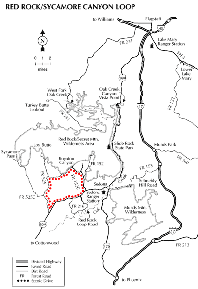
This map provides a general overview of the scenic route and nearby forest roads. Because road designations, closures and surface conditions can change, use it together with current Coconino National Forest road information and official Motor Vehicle Use Maps.
Red Rock & Sycamore Canyon Scenic Drive FAQ
Where is the Red Rock and Sycamore Canyon scenic drive?
The scenic backroad area is northwest of Sedona, Arizona. Access begins from the West Sedona area and uses Forest Road 525 and connecting forest roads toward Boynton Pass, Palatki Heritage Site and the Sycamore Canyon area.
Are the roads paved?
No. Much of the route uses unpaved forest roads. Road surfaces range from maintained gravel to rougher rocky or rutted sections, depending on the road and recent weather.
Do you need a four-wheel-drive vehicle?
Not every forest road in the area requires four-wheel drive, but some routes may be better suited to high-clearance vehicles. Always check current Forest Service road conditions and choose roads appropriate for your vehicle.
Can passenger cars drive the scenic route?
Some unpaved roads in the Sedona backcountry can be traveled by ordinary street-legal passenger vehicles when conditions are dry and well maintained. Other roads may be too rough, rocky or muddy. Conditions can change quickly.
How long should you allow for the drive?
Plan on several hours for a relaxed scenic outing and longer if you add hiking, photography, Palatki Heritage Site or other side trips. Unpaved-road travel is considerably slower than highway driving.
What can you see along the route?
The area offers red rock cliffs, desert scenery, trailheads, wilderness views and access to attractions such as Palatki Heritage Site, Boynton Canyon and portions of the backcountry adjoining Sycamore Canyon Wilderness.
Is Palatki Heritage Site along the route?
Palatki Heritage Site is reached from the same general forest-road network northwest of Sedona. Timed reservations are currently required for Palatki, so check current visitor information before including it in your drive.
Can the roads close after storms?
Yes. Rain, snow, flooding, wildfire activity and road damage can result in temporary closures or unsafe driving conditions. Check current Coconino National Forest information before entering the backcountry.
Is cell service reliable?
Cellular service can be limited or unavailable in portions of the forest-road network, so download maps and important information before leaving Sedona.
Should I rely on the map on this page for navigation?
The map is useful for general orientation, but travelers should also consult current Forest Service maps, road-status information and the Motor Vehicle Use Map before driving unpaved routes.
See All Sedona Has To Offer
Red Rock Sycamore Scenic Drive
Sedona Arizona
Coffee Pot Rock
Red Rocks Of Sedona
Sedona In Winter
History Of Sedona
50 Things To Do In Sedona
Directions From Flagstaff
Oak Creek Loop
Sedona Picnic Areas
Directions From Prescott
Cathedral Rock
Courthouse Rock
Bell Rock
Airport Mesa
Best Time To Visit











