


Oak Creek Canyon Scenic Drive on SR 89A
Reviewed and updated by AZ Leisure Staff Writers on
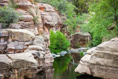
Oak Creek Narrows. © Valerie Millett
State Route 89A through Oak Creek Canyon is one of northern Arizona’s signature scenic drives, connecting Sedona with the high country near Flagstaff through a winding corridor of red-rock cliffs, pine and oak forests, and the waters of Oak Creek. Arizona officially designates this 15-mile stretch as the Sedona-Oak Creek Canyon Scenic Road, making it an excellent drive for sightseeing, photography and stops at several popular recreation areas.
- Scenic Drive Route
- Best Stops Along SR 89A
- Driving & Parking Tips
- Best Time To Drive
- Scenic Drive Map
- FAQ
Driving SR 89A Through Oak Creek Canyon
The scenic route can be driven north from Sedona toward Flagstaff or south from Flagstaff toward Sedona. Northbound travelers follow Oak Creek upstream through the forested canyon before climbing a series of steep switchbacks to the Mogollon Rim. Southbound travelers descend from the ponderosa pine country near Flagstaff, pass Oak Creek Vista and wind down the switchbacks into the canyon.
The switchback section is narrow and curving, with limited opportunities to pull over. Drive within posted speed limits, watch for changing weather and road conditions, and use designated overlooks and recreation areas rather than stopping along narrow highway shoulders.
Best Stops Along the Oak Creek Canyon Scenic Drive
Oak Creek Vista
Near the north end of the canyon, Oak Creek Vista provides expansive views across Oak Creek Canyon and the winding SR 89A corridor below. It is an ideal stop for photographs before descending the switchbacks toward Sedona or after climbing out of the canyon from the south.
West Fork of Oak Creek
The West Fork of Oak Creek Trail begins at the Call of the Canyon recreation area along SR 89A. The lower portion of the trail follows a shaded canyon beside the creek and is one of the area’s best-known hiking destinations.
Slide Rock State Park
Slide Rock State Park is one of Oak Creek Canyon’s most popular stops, known for its historic orchard, creek access and natural rock water slide. The state park charges its own entrance fee and can become especially busy during warm-weather weekends and holidays.
Oak Creek Picnic & Recreation Areas
Additional developed recreation sites along the canyon provide opportunities for picnicking, creek access, hiking and scenic viewing. Parking is limited at many locations, so arriving earlier in the day can improve your chances of finding a legal parking space.
Best Time To Drive Oak Creek Canyon
Oak Creek Canyon is scenic throughout the year, but each season offers a different experience. Spring brings mild temperatures and fresh foliage, summer provides a cool contrast to lower-elevation Arizona destinations, and autumn can bring colorful leaves to the canyon’s oaks and other deciduous trees. Winter conditions can occasionally bring snow, ice and difficult driving on SR 89A, particularly near the upper canyon and Flagstaff.
Weekends, holidays and peak recreation periods can bring heavy traffic and full parking areas. For a quieter drive and easier access to recreation sites, consider visiting earlier in the day or during a weekday.
Hiking Along the Scenic Drive
The West Fork of Oak Creek Trail is one of the most popular hikes accessible from SR 89A. The maintained lower trail follows the creek through a narrow canyon with forest shade, canyon walls and repeated creek crossings. Visitors planning to travel beyond the maintained portion should understand that conditions become substantially more difficult and require additional preparation.
Oak Creek Canyon also provides access to other short trails, picnic areas and creekside recreation. Check current Forest Service conditions, parking requirements and recreation fees before setting out.
Approaching Sedona From Oak Creek Canyon
As SR 89A leaves the narrow canyon and approaches Sedona, the landscape opens to views of the area’s distinctive red-rock formations. From Uptown Sedona, travelers can continue to restaurants, shops, trailheads, lodging and many of the area’s best-known attractions.
Visitors continuing their trip can explore additional scenic routes, including State Route 179 south through the Village of Oak Creek toward Interstate 17.
Driving & Parking Tips
For a paved return route to Flagstaff, drivers can continue south through Sedona and follow State Route 179 to Interstate 17, then travel north on I-17. Travelers who simply want to experience Oak Creek Canyon can also turn around at an appropriate location and drive SR 89A in the opposite direction.
Traffic, construction, wildfire activity, winter weather and rockfall can occasionally affect SR 89A. Before starting the drive, check current road conditions through Arizona 511, especially during winter storms, wildfire season or periods of highway construction.
Use designated parking areas when stopping to hike, picnic or access Oak Creek. Parking along unsafe highway shoulders can create hazards, and recreation sites may fill during weekends and holidays.
The drive through Oak Creek Canyon can be enjoyed as a one-way trip between Sedona and Flagstaff, an out-and-back excursion, or as part of a longer paved loop using SR 179 and Interstate 17. Allow extra time for overlooks, recreation stops, traffic and photography rather than treating the route simply as a point-to-point drive.
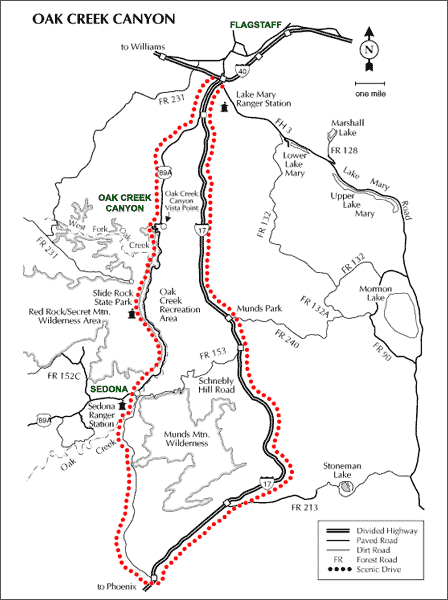
Oak Creek Canyon Scenic Drive Map
West Fork Trail in Oak Creek Canyon Video
Photos courtesy of Valerie Millett.
Oak Creek Canyon Related Information
- Hiking West Fork of Oak Creek
- Slide Rock State Park
- Sedona & Oak Creek Canyon Picnic Areas
- Coconino National Forest
Parking Fees & Recreation Passes
Parking and recreation fees vary by stop along Oak Creek Canyon. Some Forest Service fee sites require a Red Rock Pass or qualifying federal recreation pass, while locations such as Slide Rock State Park and certain concession-operated recreation areas have separate entrance or parking fees. Check the requirements for each destination before your trip.
Oak Creek Canyon Scenic Drive FAQ
Where is the Oak Creek Canyon Scenic Drive?
The scenic drive follows State Route 89A between Sedona and the high country south of Flagstaff, Arizona. The officially designated Sedona-Oak Creek Canyon Scenic Road covers approximately 15 miles.
Can you drive from Sedona to Flagstaff through Oak Creek Canyon?
Yes. State Route 89A normally connects Sedona and Flagstaff through Oak Creek Canyon. The highway includes a narrow, winding switchback section near the north end of the canyon, so check current road conditions before traveling.
How long does it take to drive Oak Creek Canyon?
The scenic portion can be driven relatively quickly without stops, but visitors should allow considerably more time if they plan to stop at overlooks, recreation sites, hiking trails or Slide Rock State Park.
What are the best stops along Oak Creek Canyon?
Popular stops include Oak Creek Vista, West Fork of Oak Creek, Slide Rock State Park and several picnic and recreation areas along SR 89A.
Is Oak Creek Canyon Scenic Drive paved?
Yes. State Route 89A through Oak Creek Canyon is paved. The road is narrow and winding in places, particularly through the switchbacks near the north end of the canyon.
Is Oak Creek Canyon difficult to drive?
Most passenger vehicles can travel SR 89A under normal road conditions, but drivers should be comfortable with curves, steep grades and narrow sections. Snow, ice, construction, wildfire activity or rockfall can occasionally affect travel.
Do you need a Red Rock Pass for Oak Creek Canyon?
A pass is not required simply to drive SR 89A, but some Forest Service recreation and parking sites require a Red Rock Pass or qualifying federal recreation pass. State parks and certain concession-operated areas may charge separate fees.
What is the best time to drive Oak Creek Canyon?
The route is scenic year-round. Spring and autumn are especially attractive for mild weather and seasonal foliage, while summer is popular for creek recreation. Winter can bring snow or icy conditions at higher elevations.
Can you drive Schnebly Hill Road instead of SR 179 and Interstate 17?
Schnebly Hill Road is an unpaved, primitive Forest Service route for which high-clearance vehicles are recommended. It should not be considered a normal paved alternative for passenger vehicles traveling between Sedona and Interstate 17.
See All Sedona Has To Offer
Oak Creek Canyon Scenic Drive
Sedona Arizona
Coffee Pot Rock
Red Rocks Of Sedona
Sedona In Winter
History Of Sedona
50 Things To Do In Sedona
Directions From Flagstaff
Sedona Picnic Areas
Directions From Prescott
Cathedral Rock
Sedona Weather
Courthouse Rock
Bell Rock
Airport Mesa
Best Time To Visit
Sedona Annual Events
Grasshopper Point
Sedona In Autumn
Directions To Sedona
Directions From Phoenix
Red Rock Sycamore Loop
Sedona Tours
Sedona Air Tours
Chapel Of The Holy Cross
Miles From Sedona
Arizona State Map
Shuttles & Transportation
Sedona Pictures
More Sedona Pictures
Sedona Video
About Sedona











