


Sedona Arizona Map & Driving Directions
Reviewed and updated by AZ Leisure Staff Writers on
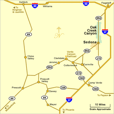 Map of Sedona Arizona Area
Use this Sedona, Arizona area map to see Sedona in relation to Oak Creek Canyon, Flagstaff, Cottonwood, Jerome, Clarkdale, Camp Verde, Prescott and other destinations in northern and central Arizona. The map also shows the major highways used to reach Sedona, including State Route 89A, State Route 179 and Interstate 17.
- Sedona Area Map
- Driving Directions
- Major Roads & Nearby Towns
- Interactive Google Map
- Travel Planning
- Visitor Information
- FAQ
Understanding the Sedona Area Map
Sedona lies in Arizona’s Verde Valley region between Flagstaff to the north and the Cottonwood-Camp Verde area to the southwest and south. State Route 89A passes through Sedona and continues north through Oak Creek Canyon toward Flagstaff and southwest toward Cottonwood and Jerome. State Route 179 connects Sedona with Interstate 17 to the southeast.
The map is useful for planning trips between Sedona and nearby destinations such as the Village of Oak Creek, Cottonwood, Jerome, Clarkdale, Camp Verde, Prescott, Flagstaff and the Grand Canyon.
Driving Directions To Sedona
From Phoenix and Scottsdale
Sedona is approximately 113 to 120 miles north of the Phoenix area, depending on your starting point. Take Interstate 17 north toward Flagstaff to Exit 298, then follow State Route 179 west and north through the Village of Oak Creek into Sedona.
From Flagstaff
The scenic route from Flagstaff follows State Route 89A south through Oak Creek Canyon into Sedona and is approximately 30 miles. An alternate route follows Interstate 17 south to Exit 298 and then State Route 179 north into Sedona. The I-17 route is longer but can be useful when conditions affect State Route 89A.
Major Roads & Nearby Towns
- State Route 89A: Runs through Sedona, north through Oak Creek Canyon toward Flagstaff and southwest toward Cottonwood and Jerome.
- State Route 179: Connects Sedona and the Village of Oak Creek with Interstate 17 at Exit 298.
- Interstate 17: The main north-south freeway connecting the Phoenix area, Verde Valley and Flagstaff.
- Cottonwood: Located southwest of Sedona in the Verde Valley and reached primarily by State Route 89A.
- Jerome: Located beyond Cottonwood on State Route 89A and popular as a Sedona day-trip destination.
- Camp Verde: Located southeast of Sedona near Interstate 17 and State Route 260.
- Flagstaff: Located north of Sedona and reached by scenic State Route 89A or by State Route 179 and Interstate 17.
Interactive Map of Sedona Arizona
Sedona Travel Planning
- Directions To Sedona
- Driving Directions From Phoenix
- Driving Directions From Flagstaff
- Distance and Directions From Prescott
- Driving Distances From Sedona
- Getting To Grand Canyon South Rim
- Arizona State Map
- Sedona Shuttles & Transportation
- Sedona Weather
Tips For Driving Around Sedona
- Check current road conditions before traveling through Oak Creek Canyon or other mountain routes.
- Allow extra time during weekends, holidays and peak visitor periods when traffic can be heavier.
- State Route 89A through Oak Creek Canyon is scenic but includes curves, grades and slower sections.
- State Route 179 includes several roundabouts as it approaches and passes through the Sedona area.
- Winter weather can affect roads between Sedona and Flagstaff because of the higher elevation.
- Wildfires, storms, construction or other incidents can occasionally require alternate routes.
Sedona Visitor Information Center
The Sedona Visitor Information Center is located at 331 Forest Road in Uptown Sedona. Visitors can obtain maps, directions, transportation information and assistance planning activities throughout Sedona and the Verde Valley.
For current hours, telephone information and visitor services, visit the official Sedona Visitor Information Center.
Sedona Arizona Map & Directions FAQ
Where is Sedona, Arizona?
Sedona is located in north-central Arizona in the Verde Valley region, south of Flagstaff and north of Cottonwood and Camp Verde.
What highway goes through Sedona?
State Route 89A is the primary highway through Sedona. State Route 179 enters Sedona from the southeast and connects the city with Interstate 17 at Exit 298.
How far is Sedona from Phoenix?
Sedona is approximately 113 to 120 miles from the Phoenix area, depending on the starting point. The primary route follows Interstate 17 north to Exit 298 and then State Route 179 into Sedona.
How far is Sedona from Flagstaff?
Sedona is approximately 30 miles from Flagstaff by State Route 89A through Oak Creek Canyon. An alternate route uses Interstate 17 and State Route 179 and is longer.
What is the scenic route from Flagstaff to Sedona?
State Route 89A through Oak Creek Canyon is the scenic route between Flagstaff and Sedona. The highway descends through the canyon before entering Uptown Sedona.
What exit do you take from Interstate 17 to Sedona?
Travelers using State Route 179 generally take Interstate 17 Exit 298 and follow SR 179 toward Sedona.
What towns are near Sedona?
Nearby communities include the Village of Oak Creek, Cottonwood, Clarkdale, Jerome and Camp Verde. Flagstaff is located to the north beyond Oak Creek Canyon.
Where can I check current road conditions before driving to Sedona?
Check current Arizona highway conditions before traveling, particularly when winter weather, wildfires, storms or construction could affect State Route 89A, State Route 179 or Interstate 17.
See All Sedona Has To Offer
Sedona Arizona Map
Sedona Arizona
Coffee Pot Rock
Red Rocks Of Sedona
Sedona In Winter
History Of Sedona
50 Things To Do In Sedona
Directions From Flagstaff
Oak Creek Loop
Sedona Picnic Areas
Directions From Prescott
Cathedral Rock
Sedona Weather
Courthouse Rock
Bell Rock
Airport Mesa
Best Time To Visit
Sedona Annual Events
Grasshopper Point
Sedona In Autumn
Directions To Sedona
Directions From Phoenix
Red Rock Sycamore Loop
Sedona Tours
Sedona Air Tours
Chapel Of The Holy Cross
Miles From Sedona
Arizona State Map
Shuttles & Transportation
Sedona Pictures
More Sedona Pictures
Sedona Video
About Sedona











