


Sedona Hiking Trails & Trailhead Map
Reviewed and updated by AZ Leisure Staff Writers on
Sedona is surrounded by an extensive network of hiking trails through red rock canyons, high-desert mesas, forested slopes and creek corridors. This Sedona hiking trails map helps locate popular trailheads and hiking areas in Sedona, Oak Creek Canyon, Red Rock Country and nearby Wet Beaver Creek. Routes range from short, easy walks to strenuous backcountry hikes, making it useful to review trail length, difficulty, elevation, parking and current conditions before heading out. See our guide to Sedona area hiking trails for additional trail descriptions.
- Sedona Hiking Trails Map
- Major Hiking Areas
- Parking & Red Rock Pass
- Sedona Trailhead Shuttle
- Planning Your Hike
- Hiking Safety Tips
- FAQ
Sedona Hiking Trails Map
The map below shows the general locations of hiking trails and trailheads throughout the Sedona area. Use it as a planning overview, then check current trail information, road access and parking conditions before beginning your hike. Some trailheads are located at designated Forest Service fee sites where a Red Rock Pass or qualifying federal recreation pass is required, while other trailheads do not require a recreation pass.
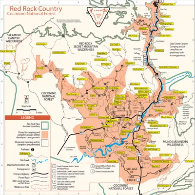 Map of hiking trails and trailheads in Sedona and Red Rock Country
Major Sedona Hiking Areas
Sedona’s trail system covers several distinct landscapes, each offering a different hiking experience.
- West Sedona — access to popular trails near Dry Creek, Mescal, Boynton Canyon, Bear Mountain and Devil’s Bridge.
- Red Rock Crossing & Cathedral Rock — trails around Cathedral Rock, Baldwin Trail, Oak Creek and Red Rock Crossing.
- Village of Oak Creek — Bell Rock, Courthouse Butte, Big Park and surrounding red rock trails.
- Oak Creek Canyon — forested hiking along Oak Creek, including West Fork and trails climbing toward the canyon rim.
- Uptown & Schnebly Hill — trails including Huckaby, Munds Wagon and routes extending into the surrounding red rock country.
- Wet Beaver Creek Area — hiking east and southeast of Sedona with creekside routes and more remote backcountry terrain.
Trailhead Parking & The Red Rock Pass
A Red Rock Pass is required when you park and leave your vehicle at designated Forest Service fee sites in Red Rock Country. Not every Sedona trailhead is a fee site, so check the signs at the parking area before purchasing a pass. America the Beautiful and other qualifying federal recreation passes are also accepted at many Forest Service fee sites.
Red Rock Passes are available at many fee-site vending machines, the Red Rock Ranger District Visitor Center and through Recreation.gov. State parks, concession-operated recreation areas and other independently managed sites may charge separate fees that are not covered by the standard Red Rock Pass.
Sedona Trailhead Shuttle
The free Sedona Shuttle provides access to several of the area’s busiest trailheads and can eliminate the need to search for limited trailhead parking. Current shuttle destinations include Cathedral Rock, Little Horse, Soldier Pass, Mescal and Dry Creek Vista, which provides access toward Devil’s Bridge.
Trailhead Shuttle routes generally operate Thursday through Sunday year-round, with expanded service during selected holidays and peak travel periods. Some trailhead parking areas may be closed to private vehicles while shuttle service is operating, so check the current schedule before driving to the trailhead.
Check current Sedona Shuttle trailhead routes and schedules.
Planning A Sedona Hike
Use the map to identify the general location of a trail, but review current trail information before leaving. Distances, elevation gain, exposure and trail conditions vary widely across Sedona’s trail system. Summer heat, winter ice, monsoon storms and temporary closures can all affect hiking conditions.
- Check the trail distance, elevation gain and difficulty before starting.
- Confirm whether the trailhead requires a Red Rock Pass or another parking fee.
- Check whether the Sedona Shuttle serves the trailhead.
- Carry more drinking water than you expect to need.
- Start early during warm months to avoid the hottest part of the day.
- Wear sturdy footwear appropriate for rocky and uneven terrain.
- Download or carry a trail map because cell service can be unreliable.
- Check current Forest Service alerts, closures and weather before hiking.
Sedona Hiking Safety Tips
Sedona’s scenery can make relatively short hikes feel deceptively easy, but heat, steep terrain and limited shade can quickly create difficult conditions. Choose a route appropriate for your fitness level and allow enough time to return before dark.
- Carry plenty of water and drink regularly, even during cooler weather.
- Use sunscreen, a hat and protective clothing on exposed trails.
- Avoid exposed ridges, summits and open slickrock when thunderstorms are nearby.
- Do not rely exclusively on a mobile phone for navigation.
- Tell someone where you are hiking and when you expect to return.
- Stay on established trails to protect fragile desert vegetation and soils.
- Do not enter closed trails or recreation areas.
- Turn around if weather, heat, fatigue or trail conditions become unsafe.
Check Current Trail Conditions Before You Go
Trail access, roads and recreation sites around Sedona can temporarily close because of wildfire, flooding, maintenance or other public-safety concerns. Before hiking, check current Coconino National Forest alerts and Sedona Shuttle information rather than relying solely on a printed or static map.
More Sedona Hiking Information
- Sedona Area Hiking Trails
- Oak Creek Hiking Trail
- Boynton Canyon Trail
- Bell Trail
- A. B. Young Trail
- Sedona Monthly Weather & Temperatures
- Best Time To Visit Sedona
- Sedona Campgrounds
Sedona Hiking Trails Map FAQ
Where can I find a map of Sedona hiking trails?
The map on this page shows the general locations of hiking trails and trailheads throughout Sedona, Oak Creek Canyon and surrounding Red Rock Country. Detailed Forest Service and individual trail maps should also be consulted for navigation.
Do all Sedona hiking trails require a Red Rock Pass?
No. A Red Rock Pass or qualifying federal recreation pass is required at designated Forest Service fee sites, but not every Sedona trailhead is a fee site. Check signs at the parking area before beginning your hike.
Which Sedona trailheads are served by the free shuttle?
The Sedona Shuttle currently serves Cathedral Rock, Little Horse, Soldier Pass, Mescal and Dry Creek Vista, which provides access toward Devil’s Bridge.
Does the Sedona Shuttle run every day?
Trailhead Shuttle routes generally operate Thursday through Sunday, with additional service during selected holidays and busy travel periods. Check the current schedule before your hike.
Can I park at Cathedral Rock Trailhead?
Parking access can be restricted while Sedona Shuttle service is operating. When restrictions are in effect, hikers should use the designated Park & Ride and shuttle service.
What are the easiest hiking areas around Sedona?
Several trails near Bell Rock, Courthouse Butte and other developed trailheads offer relatively easy options, but hikers should always check current trail length, elevation and difficulty before starting.
What are some popular hiking areas in West Sedona?
West Sedona provides access to trails around Dry Creek, Mescal, Boynton Canyon, Bear Mountain and Devil’s Bridge.
When is the best time to hike in Sedona?
Spring and fall generally offer comfortable hiking temperatures, while winter can be cool or icy and summer can be extremely hot. During warmer months, early-morning hiking is strongly recommended.
How much water should I bring hiking in Sedona?
Water needs vary with temperature, distance and individual fitness, but hikers should carry more water than they expect to need and increase the amount during warm weather or strenuous hikes.
Should I check trail conditions before hiking?
Yes. Wildfire, flooding, road conditions, maintenance and other events can temporarily close trails or recreation sites. Check current Forest Service alerts and local transportation information before leaving.
Enjoy Hiking In The Sedona Area











