Getting To Sedona From Phoenix
 Magical Sedona Light. © Mike Koopsen
Approximate driving distance is 120 miles. But the distance originating from the East Valley areas could be 135 to 160 miles. It is a scenic drive of 2 to 2.5 hours that takes you through North Phoenix along mesas saturated with stands of Saguaro cactus.
Take Interstate 17 Freeway North. At Black Canyon City, there is a short, steep climb to the top of the rim. After reaching the rim, keep an eye for roaming herds of antelope.
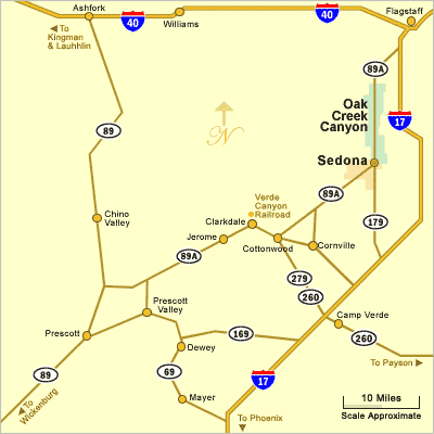
Take Exit 298 North (left) on State Route Highway 179. Exit 298 from I-17 is just north of Camp Verde. SR 179 is a designated "All American Road".
Travel on SR 179 for about 14 miles to State Route 89A. Then veer right into Sedona. The intersection of 179 and 89A is known as the "Y".
The elevation climb is from about 1100 feet in Phoenix to about 4,500 feet in Sedona. It will be 10 to 15 degrees cooler in Sedona versus Phoenix. See Sedona Arizona Weather Charts showing average temperatures by month of the year. During the winter months, Sedona can be dusted with snow.
Sedona Area Map
Helpful Information
See All Sedona Has To Offer
Sedona Annual Events
Grasshopper Point
Sedona In Autumn
Directions To Sedona
Directions To Phoenix
Red Rock Sycamore Loop
Sedona Tours
Sedona Air Tours
Chapel Of The Holy Cross
Miles From Sedona
Arizona State Map
Shuttles & Transportation
Sedona Pictures
More Sedona Pictures
Sedona Video
About Sedona