


Sedona Hiking Trails & Red Rock Country Hikes
Reviewed and updated by AZ Leisure Staff Writers on
Sedona offers one of Arizona’s most diverse hiking destinations, with trails winding through red rock canyons, high-desert mesas, creek corridors and forested slopes. Hikes range from short scenic walks to strenuous climbs with substantial elevation gain, and popular areas include West Sedona, Oak Creek Canyon, Cathedral Rock, Bell Rock, Boynton Canyon and the surrounding Red Rock Country. Use this guide to compare hiking areas and difficulty levels, then visit our Sedona hiking trails map to locate trailheads, parking areas and major trail regions.
- Choosing A Sedona Trail
- Sedona Hiking Trails
- Popular Hiking Areas
- Trail Difficulty
- Parking, Passes & Shuttle
- Best Time To Hike
- Hiking Safety
- FAQ
Choosing A Sedona Hiking Trail
The best Sedona hike depends on how much time you have, your fitness level, the season and the scenery you want to experience. Some trails follow relatively gentle red rock terrain, while others climb steeply to saddles, canyon rims and overlooks. Before hiking, check the distance, elevation gain, trail difficulty, parking situation and current conditions. For official trail information and current alerts, visit the Coconino National Forest.
Sedona Hiking Trails At A Glance
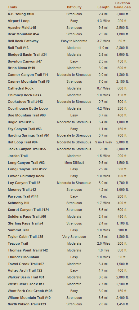
The chart below provides a quick comparison of Sedona-area hiking trails. Use it as a starting point for selecting a hike, then review current trail information before heading out because access, parking, trail conditions and closures can change.
Popular Sedona Hiking Areas
West Sedona
West Sedona provides access to some of the area’s best-known hiking country, including Boynton Canyon, Mescal, Dry Creek, Bear Mountain and routes leading toward Devil’s Bridge. Trails range from relatively moderate walks to demanding climbs.
Cathedral Rock & Red Rock Crossing
The Cathedral Rock area combines iconic red rock scenery with trails near Oak Creek. Cathedral Rock itself involves a steep climb, while nearby Baldwin Trail and Red Rock Crossing provide additional ways to explore the area.
Bell Rock & Village of Oak Creek
Bell Rock, Courthouse Butte and the surrounding trail network provide numerous interconnected routes and are especially useful for hikers who want a choice of shorter or longer outings.
Oak Creek Canyon
Oak Creek Canyon offers a different environment from Sedona’s open red rock terrain, with forested trails, creekside scenery and cooler conditions. West Fork is one of the best-known hikes in the canyon.
Schnebly Hill & Uptown Sedona
Trails east and northeast of central Sedona include routes such as Munds Wagon and Huckaby, with access to expansive red rock scenery and views across the Sedona basin.
Understanding Sedona Trail Difficulty
Trail difficulty is influenced by more than elevation gain. Distance, steepness, footing, exposure, route-finding, scrambling and seasonal conditions can all make a hike more demanding. A short trail with steep slickrock may be more challenging than a longer trail with gradual elevation gain.
- Easy trails generally have shorter distances, modest elevation changes and relatively straightforward footing.
- Moderate trails may include longer distances, sustained climbing, rocky terrain or sections requiring greater endurance.
- Strenuous trails may involve steep elevation gain, exposed terrain, scrambling, long distances or difficult route conditions.
Always evaluate a trail based on your own experience, fitness level and current weather conditions rather than relying solely on a difficulty label.
Trailhead Parking, Red Rock Passes & The Sedona Shuttle
Parking can be limited at many popular Sedona trailheads. A Red Rock Pass or qualifying federal recreation pass is required at designated Forest Service fee sites, but not every trailhead is a fee site. Always check posted signs at the parking area.
The free Sedona Shuttle currently serves Cathedral Rock, Little Horse, Soldier Pass, Mescal and Dry Creek Vista, which provides access toward Devil’s Bridge. Trailhead routes generally operate Thursday through Sunday, with additional service during selected peak periods.
For detailed trailhead locations, parking guidance and shuttle planning, see our Sedona Hiking Trails & Trailhead Map.
Best Time To Hike In Sedona
Sedona can be hiked year-round, but conditions vary considerably by season. Spring and fall generally provide the most comfortable daytime temperatures and are also among the busiest hiking seasons. Summer hikes are best started early in the morning because exposed red rock terrain can become extremely hot. Winter can provide excellent hiking conditions at lower elevations, but snow and ice sometimes affect shaded trails, higher elevations and Oak Creek Canyon.
- Spring: Mild temperatures and popular hiking conditions; expect busy trailheads.
- Summer: Start early, carry abundant water and avoid exposed trails during extreme heat.
- Fall: Comfortable temperatures and excellent hiking conditions throughout much of Red Rock Country.
- Winter: Often pleasant at lower elevations, but shaded and higher trails may have snow or ice.
Sedona Hiking Safety
Sedona’s dramatic scenery can distract from the challenges of desert hiking. Heat, dehydration, thunderstorms, steep slickrock and limited shade can turn an otherwise manageable hike into a difficult situation.
- Carry plenty of drinking water and more than you expect to need.
- Wear sturdy footwear appropriate for rocky and uneven terrain.
- Use sunscreen, protective clothing and a hat on exposed trails.
- Begin early during hot weather and avoid strenuous midday hiking during extreme heat.
- Watch for rapidly developing thunderstorms and avoid exposed ridges during lightning.
- Carry a map or downloaded route because cellular service may be unreliable.
- Tell someone where you are hiking and when you expect to return.
- Stay on established trails and respect all temporary closures.
Featured Sedona Hikes
- Boynton Canyon Trail
- Oak Creek Hiking Trail
- Bell Trail
- A. B. Young Trail
- West Fork Trail
- Sedona Hiking Trails & Trailhead Map
Sedona Hiking Trails FAQ
What are the best hiking trails in Sedona?
Popular choices include trails around Cathedral Rock, Bell Rock, Boynton Canyon, West Fork, Devil’s Bridge, Bear Mountain and the Dry Creek area. The best trail depends on the scenery, distance and difficulty you prefer.
Are there easy hiking trails in Sedona?
Yes. Sedona has a variety of shorter and relatively easy trails, particularly around developed trail systems such as Bell Rock and Courthouse Butte. Always check current distance, elevation gain and trail conditions before hiking.
What are the most difficult hikes in Sedona?
Some Sedona routes involve steep climbs, substantial elevation gain, exposed terrain or scrambling. Bear Mountain and other steep canyon and mesa routes can be particularly demanding.
Do I need a Red Rock Pass to hike in Sedona?
A Red Rock Pass or qualifying federal recreation pass is required when parking at designated Forest Service fee sites. Not every Sedona trailhead requires a recreation pass.
Is there a shuttle to Sedona hiking trails?
Yes. The free Sedona Shuttle currently provides service to Cathedral Rock, Little Horse, Soldier Pass, Mescal and Dry Creek Vista, with access toward Devil’s Bridge.
When is the best time of year to hike in Sedona?
Spring and fall generally provide the most comfortable hiking weather. Summer requires extra precautions because of heat, while winter may bring snow or ice to shaded and higher-elevation trails.
Can you hike in Sedona during summer?
Yes, but hikers should start early, carry plenty of water and avoid strenuous exposed hikes during the hottest part of the day.
Are Sedona hiking trails well marked?
Many popular trails are signed and established, but junctions and interconnected trail systems can still be confusing. Carry a map or downloaded route and do not rely exclusively on cellular service.
What should I bring on a Sedona hike?
Bring plenty of water, sturdy footwear, sun protection, appropriate clothing and a map or downloaded trail route. Longer or more remote hikes may require additional emergency supplies.
Where can I find a map of Sedona hiking trails?
See our Sedona Hiking Trails & Trailhead Map for trail locations, major hiking areas, parking information, Red Rock Pass guidance and Sedona Shuttle information.
Enjoy Hiking In The Sedona Area











