


Directions From Prescott To Sedona Arizona
Reviewed and updated by AZ Leisure Staff Writers on
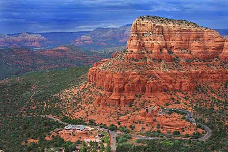 Chapel of Holy Cross Below Courthouse Rock in Sedona Arizona. © Mike Koopsen
Prescott and Sedona are connected by two useful driving routes through central Arizona. Travelers can follow scenic State Route 89A through the mountains, Jerome and Cottonwood, or use State Route 69, State Route 169, Interstate 17 and State Route 179 for an alternate approach to Sedona. Mileage and travel time vary depending on the route, traffic, weather and your exact starting and ending points.
- Prescott To Sedona Overview
- Scenic Route Via Jerome
- Route Via I-17
- Compare The Routes
- Road Conditions
- Sedona Area Map
- Google Map
- FAQ
Prescott To Sedona Driving Overview
The drive from Prescott to Sedona is generally about 60 to 70 miles, depending on the route and your exact starting and ending points. Plan on roughly 1.5 hours of driving under favorable conditions, although traffic, construction, weather and stops can increase travel time.
The scenic State Route 89A route travels through Mingus Mountain, Jerome and Cottonwood before reaching Sedona. An alternate route uses State Route 69, State Route 169, Interstate 17 and State Route 179.
Scenic Route From Prescott To Sedona Via Jerome
For the most scenic drive, follow State Route 89A northeast from the Prescott area toward Mingus Mountain and Jerome. Continue on SR 89A through Clarkdale and Cottonwood, then follow the highway northeast into Sedona.
This route passes through mountain terrain and several designated scenic and historic highway segments, including the Mingus Mountain Scenic Road and the Jerome-Clarkdale-Cottonwood Historic Road. The highway is winding in places, particularly around Mingus Mountain and Jerome, so allow extra time and drive cautiously.
- Follow State Route 89A from the Prescott area toward Mingus Mountain.
- Continue on SR 89A through Jerome.
- Follow SR 89A through Clarkdale and Cottonwood.
- Remain on SR 89A northeast toward Sedona.
Prescott To Sedona Via Interstate 17
An alternate route from Prescott uses State Route 69 east toward Prescott Valley and Cordes Junction, State Route 169 north to Interstate 17, and Interstate 17 north to Exit 298. From Exit 298, follow State Route 179 north through the Village of Oak Creek into Sedona.
- Follow State Route 69 east from Prescott.
- Turn north onto State Route 169.
- Merge onto Interstate 17 north.
- Take Exit 298 for State Route 179.
- Follow State Route 179 north into Sedona.
Which Prescott To Sedona Route Should You Take?
- For scenery: Choose State Route 89A through Mingus Mountain, Jerome and Cottonwood.
- For a more highway-oriented drive: Use State Route 69, State Route 169, Interstate 17 and State Route 179.
- For nervous mountain drivers: The I-17 route avoids the tightest sections around Mingus Mountain and Jerome.
- For sightseeing: The SR 89A route provides convenient opportunities to stop in Jerome, Clarkdale and Cottonwood.
- During poor weather or road restrictions: Check current highway conditions before choosing either route.
Check Road Conditions Before Driving
Weather, construction, wildfire activity, traffic incidents and seasonal congestion can affect highways between Prescott and Sedona. Check current Arizona road conditions shortly before departure, especially when traveling across Mingus Mountain or during winter weather.
Map Of The Sedona And Verde Valley Area
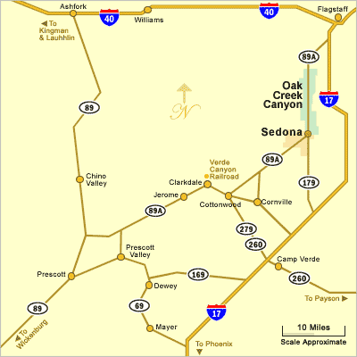
Google Map From Prescott To Sedona
More Sedona Driving Information
- Directions To Sedona Arizona
- Phoenix To Sedona Directions
- Flagstaff To Sedona Directions
- Distances From Sedona
- Sedona Arizona Map
- Arizona State Map
Prescott To Sedona Directions FAQ
How far is Prescott from Sedona?
The driving distance is generally about 60 to 70 miles depending on the route and your exact starting and ending points.
How long does it take to drive from Prescott to Sedona?
Plan on roughly 1.5 hours under favorable driving conditions. Traffic, weather, construction and sightseeing stops can increase travel time.
What is the most scenic route from Prescott to Sedona?
State Route 89A through Mingus Mountain, Jerome, Clarkdale and Cottonwood is the most scenic route between Prescott and Sedona.
Can I drive from Prescott to Sedona using Interstate 17?
Yes. An alternate route follows State Route 69 and State Route 169 to Interstate 17, then Interstate 17 north to Exit 298 and State Route 179 into Sedona.
Does the scenic route from Prescott to Sedona go through Jerome?
Yes. State Route 89A passes through Jerome before continuing through Clarkdale and Cottonwood toward Sedona.
Is State Route 89A between Prescott and Sedona winding?
Yes. The highway contains winding mountain sections, especially around Mingus Mountain and Jerome, so drivers should allow extra time and use caution.
Which route is better for drivers who prefer major highways?
The State Route 69, State Route 169, Interstate 17 and State Route 179 route provides a more highway-oriented alternative to the winding SR 89A route.
Should I check road conditions before driving from Prescott to Sedona?
Yes. Weather, construction, wildfire activity and traffic incidents can affect both routes. Check AZ 511 before leaving.
See All Sedona Has To Offer
Sedona Annual Events
Grasshopper Point
Sedona In Autumn
Directions To Sedona
Directions From Phoenix
Red Rock Sycamore Loop
Sedona Tours
Sedona Air Tours
Chapel Of The Holy Cross
Miles From Sedona
Arizona State Map
Shuttles & Transportation
Sedona Pictures
More Sedona Pictures
Sedona Video
About Sedona











