


Courthouse Butte Loop Trail In Sedona
Reviewed and updated by AZ Leisure Staff Writers on
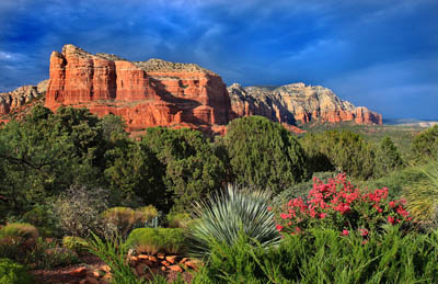 Courthouse Butte. © Mike Koopsen
Courthouse Butte is one of the prominent red rock landmarks south of Sedona, Arizona, rising immediately east of Bell Rock along State Route 179. The Courthouse Butte Loop Trail circles the formation through open red rock country, providing changing views of Courthouse Butte, Bell Rock and the surrounding landscape on an approximately 4.3-mile hike.
- Trail Overview
- Hiking The Loop
- Trail Details
- What You Will See
- Name & History
- Parking & Trailhead
- Directions
- Hiking Tips
- FAQ
Courthouse Butte Loop Trail Overview
The Courthouse Butte Loop is a scenic hike through the red rock country south of Sedona near Bell Rock and the Village of Oak Creek. The Forest Service lists the loop at approximately 4.3 miles round trip with about 350 feet of cumulative elevation gain and rates the hike as easy.
The route begins along the broad Bell Rock Pathway before branching onto the narrower Courthouse Butte Loop Trail. Much of the hike is exposed to the sun, and shade is limited, making water and sun protection especially important during warmer months.
Hiking The Courthouse Butte Loop
From the Bell Rock Vista area, follow the wide Bell Rock Pathway toward Bell Rock. After approximately one-half mile, the route reaches the signed Courthouse Butte Loop Trail. The loop can be hiked in either direction, although the Forest Service trail description follows it clockwise.
The trail passes beneath Bell Rock before continuing around the broad slopes and cliffs of Courthouse Butte. As the route moves east and north, the busy Bell Rock area gives way to quieter desert scenery and narrower single-track trail.
Part of the route enters the Munds Mountain Wilderness, where bicycles are prohibited. Horses are prohibited on the Bell Rock Pathway. Hikers should remain on designated trails and respect wilderness and private-property boundaries.
The final portion of the loop reconnects with Bell Rock Pathway for the return to the trailhead.
Courthouse Butte Loop Trail Details
- Distance: Approximately 4.3 miles round trip
- Difficulty: Easy
- Elevation gain: Approximately 350 feet cumulative
- Hiking time: Allow about 2.5 hours
- Season: Year-round, weather and trail conditions permitting
- Shade: Limited
- Water: No dependable water source along the trail
- Parking: Recreation pass required at the trailhead
- Bicycles: Prohibited within designated wilderness
- Horses: Prohibited on Bell Rock Pathway
Scenery Along The Courthouse Butte Loop
The trail provides constantly changing views as it circles Courthouse Butte. Bell Rock dominates the western portion of the route, while the eastern and northern sides of the loop offer a quieter perspective of Courthouse Butte and the surrounding high-desert landscape.
Vegetation along the route includes juniper, pinyon pine, agave, cactus and seasonal wildflowers. Open stretches also provide broad views across the red rock country surrounding the Village of Oak Creek.
How Courthouse Butte Got Its Name
The names of several Sedona red rock formations have changed or been confused on historical maps. Cathedral Rock appeared as Court House Rock on some early maps, while the formation now known as Courthouse Butte was once identified as Church House Rock.
Those early naming variations helped create lasting local stories about how Courthouse Butte, Cathedral Rock and nearby Bell Rock received their modern names.
Courthouse Butte Parking And Trailhead
The Courthouse Butte Loop is commonly accessed from the Bell Rock Vista trailhead along State Route 179 south of Sedona. Parking areas in this corridor can become busy during weekends, holidays and peak visitor periods.
A recreation pass is required at the Courthouse/Bell Rock fee sites. Check current Coconino National Forest information for accepted passes and any changes to parking requirements before your hike.
Directions To Courthouse Butte Loop Trail
From the junction of State Route 89A and State Route 179 in Sedona, travel south on State Route 179 for approximately 6.5 miles toward the Village of Oak Creek. Turn into the Bell Rock Vista trailhead area near milepost 307 and follow the Bell Rock Pathway toward Bell Rock and the Courthouse Butte Loop.
Tips For Hiking Courthouse Butte Loop
- Carry plenty of drinking water because there is no dependable water source along the route.
- Use sunscreen, a hat and other sun protection because much of the trail is exposed.
- Start early during warmer months to avoid the hottest part of the day.
- Wear footwear suitable for dirt, rock and uneven single-track trail.
- Watch for trail junctions where several routes intersect near Bell Rock.
- Stay on designated trails and avoid creating shortcuts across fragile desert terrain.
- Check current weather and trail conditions before hiking.
- Do not enter washes during storms or periods of potential flash flooding.
- Carry out all trash and leave natural and archaeological features undisturbed.
Current Courthouse Butte Trail Information
Check current trail conditions, weather, fire restrictions and recreation-pass requirements before beginning your hike.
Nearby Sedona Red Rock Hikes
Courthouse Butte Loop Trail FAQ
How long is the Courthouse Butte Loop Trail?
The Forest Service lists the Courthouse Butte Loop at approximately 4.3 miles round trip.
How difficult is the Courthouse Butte Loop?
The Forest Service rates the Courthouse Butte Loop as an easy hike, although the route includes uneven dirt and rock surfaces and has very little shade.
How much elevation gain is on the Courthouse Butte Loop?
The hike has approximately 350 feet of cumulative elevation gain.
How long does it take to hike Courthouse Butte Loop?
Allow approximately 2.5 hours for the full loop, although hiking time varies with pace, trail conditions and the amount of time spent sightseeing or taking photographs.
Where does the Courthouse Butte Loop begin?
The loop is commonly accessed from the Bell Rock Vista trailhead along State Route 179 south of Sedona. Hikers follow Bell Rock Pathway before connecting with the Courthouse Butte Loop Trail.
Is a parking pass required for Courthouse Butte?
Yes. A recreation pass is required at the Courthouse and Bell Rock fee sites. Check current Coconino National Forest information for accepted passes before visiting.
Is there water on the Courthouse Butte Loop?
No dependable drinking-water source is available along the trail, so hikers should carry enough water for the entire hike.
Can bicycles use the Courthouse Butte Loop?
Bicycles are prohibited where the route enters designated wilderness. Follow posted signs and current Forest Service trail-use regulations.
Can horses use the Courthouse Butte Loop?
Horses are prohibited on Bell Rock Pathway, which is used to access the Courthouse Butte Loop from the Bell Rock Vista area.
Can you see Bell Rock from the Courthouse Butte Loop?
Yes. Bell Rock is visible from several sections of the route, and portions of the hike provide views of both Bell Rock and Courthouse Butte.
See All Sedona Has To Offer
Sedona Annual Events
Grasshopper Point
Sedona In Autumn
Directions To Sedona
Directions From Phoenix
Red Rock Sycamore Loop
Sedona Tours
Sedona Air Tours
Chapel Of The Holy Cross
Miles From Sedona
Arizona State Map
Shuttles & Transportation
Sedona Pictures
More Sedona Pictures
Sedona Video
About Sedona











