


Airport Mesa In Sedona, Arizona
Reviewed and updated by AZ Leisure Staff Writers on
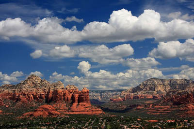
Airport Mesa is one of Sedona's most accessible places for panoramic red rock views, hiking, sunset viewing and a visit to one of the area's best-known vortex sites. Located just off Highway 89A near central Sedona, the mesa overlooks landmarks including Coffee Pot Rock, Chimney Rock, Cathedral Rock, Courthouse Butte and Bell Rock. Visitors can make a short walk to the Airport Mesa vortex and viewpoint or hike the longer Airport Loop Trail around the mesa.
- Airport Mesa Hiking Trail
- Parking & Trail Access
- Airport Mesa Vortex
- Views & Best Time To Visit
- Directions
- Airport Mesa FAQ
Hiking The Airport Mesa Loop Trail
The Airport Loop Trail circles Airport Mesa and provides nearly continuous views of Sedona's red rock country. From the Airport Road parking area, the loop is approximately 3.3 miles round trip. Although generally considered an easy-to-moderate Sedona hike, the trail is rocky in places, includes some narrow sections and is almost completely exposed to the sun.
Views change continually around the mesa. Hikers can look toward Cathedral Rock and Twin Buttes to the east and south, while the northern side provides excellent perspectives of Thunder Mountain, Chimney Rock and Coffee Pot Rock. An optional side trip on the Tabletop Trail adds roughly another mile to the hike.
Airport Mesa Parking & Trail Access
There are two commonly used access points along Airport Road. The smaller Airport Saddle parking area provides access to the vortex site and Airport Loop Trail, while the Airport Vista parking area farther up Airport Road provides another option for panoramic views and trail access. Parking is limited, especially around sunrise and sunset, so arriving early can make a visit much easier.
Visitors starting at Airport Vista can reach the Airport Loop Trail by using the Sedona View Trail. The additional approach adds distance to the hike, so allow extra time if beginning from the upper parking area.
Airport Mesa Vortex
Airport Mesa is one of Sedona's best-known vortex locations, along with Bell Rock, Cathedral Rock and Boynton Canyon. People who follow Sedona's vortex traditions describe these locations as places where the area's natural energy may enhance meditation, reflection and a sense of well-being. Others simply visit Airport Mesa for its scenery, convenient location and expansive views.
The vortex viewpoint is reached by a relatively short but rocky walk from the Airport Road parking area. Visitors may encounter people meditating, practicing yoga or quietly enjoying the setting, so respect other visitors and the surrounding landscape.
Airport Mesa Views & Best Time To Visit
Airport Mesa offers broad views in nearly every direction, making it popular for photography, sunrise and sunset. Early morning typically provides cooler hiking conditions and softer light on Sedona's red rocks, while sunset attracts visitors for the changing colors across the surrounding formations.
The trail has very little shade, so summer hikers should avoid the hottest part of the day and carry plenty of water. Sturdy footwear is helpful because portions of the route are rocky and uneven. For seasonal planning, see our Sedona weather guide and best time to visit Sedona.
Directions To Airport Mesa
From the intersection of Highway 89A and Highway 179 in central Sedona, travel west on Highway 89A and turn left onto Airport Road. Follow Airport Road uphill to the small Airport Saddle parking area for access to the vortex and Airport Loop Trail. Continue farther up Airport Road to reach the Airport Vista parking area and overlook.
Parking areas can fill quickly during popular times of day. If you plan to hike the loop, allow additional time to find legal parking and never park outside designated areas.
Airport Mesa At A Glance
- Location: Airport Road near central Sedona
- Main hike: Airport Loop Trail
- Loop distance: About 3.3 miles from the Airport Road trail access
- Difficulty: Easy to moderate
- Trail conditions: Rocky, exposed and narrow in places
- Highlights: Panoramic red rock views, vortex site, sunrise and sunset
- Shade: Very limited
- Dogs: Allowed on leash
Airport Mesa Sedona FAQ
How long is the Airport Mesa Loop Trail?
The Airport Loop Trail is approximately 3.3 miles round trip when started from the Airport Road trail access. Starting from the Airport Vista parking area adds additional hiking distance.
Is Airport Mesa a difficult hike?
The loop is generally considered easy to moderate, but hikers should expect rocky footing, narrow sections and almost no shade. Appropriate shoes and drinking water are recommended.
Where is the Airport Mesa vortex?
The Airport Mesa vortex site is reached from the small parking area along Airport Road. A short rocky trail leads from the parking area toward the vortex viewpoint.
Is Airport Mesa good for sunset?
Yes. Airport Mesa is one of Sedona's popular sunset viewpoints because of its broad views across the surrounding red rock formations. Parking can be difficult around sunset, so arriving early is recommended.
Is there parking at Airport Mesa?
Yes. A small parking area along Airport Road serves the vortex and trail, and additional parking is available farther uphill near Airport Vista. Space is limited and parking conditions or fees can change.
Can dogs hike Airport Mesa?
Yes. Dogs are permitted on the trail when kept on a leash. Because the route is exposed, owners should consider hot weather and carry sufficient water for their pets.
See All Sedona Has To Offer











