


Desert Canyon Loop Scenic Drive Near Sedona
Reviewed and updated by AZ Leisure Staff Writers on
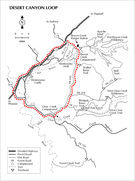
Desert Canyon Loop Scenic Drive explores the high-desert country southeast of Sedona and northeast of Camp Verde, offering a very different landscape from Sedona's famous red rock formations. The approximately 22-mile loop follows Forest Road 618 from the Interstate 17 and State Route 179 interchange to State Route 260, passing colorful canyons, desert vegetation, ranch country, trailheads and recreation areas near Wet Beaver Creek and West Clear Creek.
- Desert Canyon Loop Overview
- Driving Directions
- Scenic Highlights
- Montezuma Well Side Trip
- Road Conditions
- Recreation Along The Route
- Driving Tips
- Desert Canyon Loop Map
- FAQ
Desert Canyon Loop Scenic Drive Overview
The Desert Canyon Loop combines approximately 13 miles of Forest Road 618 with about 9 miles of paved State Route 260, forming a scenic loop east of Interstate 17. Although the basic loop covers roughly 22 miles, slow travel on the gravel road and stops for hiking, picnicking, sightseeing or side trips can turn the drive into a half-day or full-day outing.
- Loop distance: Approximately 22 miles
- Main roads: Forest Road 618 and State Route 260
- Road surface: Gravel on FR 618 and pavement on SR 260
- Allow: About 3.5 hours or longer with recreation stops and side trips
- Best for: Scenic driving, hiking, picnicking, wildlife watching and exploring high-desert country
Desert Canyon Loop Driving Directions
From Sedona, follow State Route 179 south toward Interstate 17. At the I-17 interchange, continue east beneath the interstate onto Beaver Creek Road, also known as Forest Road 618.
- Follow State Route 179 south from Sedona to Interstate 17 at Exit 298.
- Continue east beyond the interchange onto Forest Road 618.
- Follow FR 618 southeast for approximately 13 miles toward State Route 260.
- Turn right onto State Route 260 and travel west approximately 9 miles.
- Reconnect with Interstate 17 near Camp Verde to complete the scenic loop.
What You'll See Along Desert Canyon Loop
The Desert Canyon Loop skirts the lower elevations below Arizona's Mogollon Rim, where high-desert terrain is broken by creek canyons, springs and greener riparian areas. The scenery differs noticeably from central Sedona's towering red rock formations and provides a quieter look at the surrounding Verde Valley and rim country.
- Wet Beaver Creek: A perennial stream corridor with hiking and picnic opportunities.
- Beaver Creek Day Use Area: A recreation stop along FR 618 near Wet Beaver Creek.
- Bell Trail: A popular trail providing access into Wet Beaver Creek Canyon.
- V-Bar-V Heritage Site area: A culturally significant area along the FR 618 corridor.
- West Clear Creek: Another scenic canyon and recreation area near the eastern end of the loop.
- Ranch country: Open high-desert landscapes and historic ranching scenery occur throughout the drive.
Side Trip To Montezuma Well
Montezuma Well makes an excellent historical side trip while exploring the Desert Canyon Loop. The spring-fed limestone sinkhole is a separate unit of Montezuma Castle National Monument and includes prehistoric dwellings, pueblo remains and a centuries-old irrigation canal.
Montezuma Castle is another unit of the same National Monument near Camp Verde and can be added as a separate stop before or after the scenic drive. See our Montezuma Castle information for additional trip-planning details.
Forest Road 618 Conditions
Forest Road 618 is a gravel road that is generally suitable for passenger vehicles when conditions are dry. However, the surface can become soft, muddy or slippery after rain, and forest-road conditions can change because of storms, maintenance, wildfire activity or temporary closures.
Check current conditions before beginning the loop, particularly during or immediately after wet weather. Avoid driving unpaved forest roads when conditions could cause vehicle damage or damage to the road surface.
Recreation Along The Desert Canyon Loop
The loop provides access to several outdoor recreation areas where visitors can extend the scenic drive into a longer day trip. Opportunities vary by location and season.
- Hiking: Trailheads along the corridor provide access to Wet Beaver Creek and surrounding backcountry.
- Picnicking: Beaver Creek Day Use Area provides a convenient stopping point near Wet Beaver Creek.
- Swimming and wading: Creek recreation is popular when water levels and conditions are safe.
- Fishing: Wet Beaver Creek and other nearby waters provide seasonal fishing opportunities.
- Mountain biking: Forest roads and designated routes provide opportunities for backcountry riding.
- Wildlife watching: The high-desert and riparian habitats support a variety of birds and wildlife.
Desert Canyon Loop Driving Tips
- Allow plenty of time: Although the loop is only about 22 miles, slow speeds and sightseeing stops can easily turn it into a half-day trip.
- Check road conditions: FR 618 can become muddy or slippery after rain.
- Carry water: Much of the route crosses exposed high-desert terrain.
- Start with a full tank: Do not depend on finding fuel or other commercial services along the unpaved portion of the loop.
- Stay on designated roads: Use signed forest roads and respect closures and private property.
- Allow time for side trips: Hiking, picnicking and a visit to Montezuma Well can substantially extend the outing.
Desert Canyon Loop Scenic Drive Map
More Sedona Scenic Drives & Area Attractions
- Montezuma Castle National Monument
- Camp Verde Arizona
- Oak Creek Canyon Scenic Drive
- Red Rock & Sycamore Canyon Loop
- Sedona Attractions Map
- Things To Do In Sedona
- Sedona Area Attractions
Desert Canyon Loop Scenic Drive FAQ
How long is the Desert Canyon Loop Scenic Drive?
The main loop is approximately 22 miles, including about 13 miles on Forest Road 618 and about 9 miles on State Route 260.
How long should I allow for the Desert Canyon Loop?
Allow approximately 3.5 hours for a leisurely drive, and considerably longer if you stop for hiking, picnicking, sightseeing or side trips. The route can easily become a half-day or full-day outing.
Where does the Desert Canyon Loop begin?
From Sedona, follow State Route 179 south to Interstate 17 at Exit 298. Continue east beyond the interchange onto Beaver Creek Road, also known as Forest Road 618.
Is Forest Road 618 paved?
No. Much of Forest Road 618 is gravel. It is generally suitable for passenger vehicles when dry, but conditions can become soft, muddy or slippery after rain.
Do I need four-wheel drive for the Desert Canyon Loop?
Four-wheel drive is not normally required for the main Forest Road 618 route when road conditions are favorable, but conditions can change. Check current Forest Service information before traveling the loop.
What can I see along the Desert Canyon Loop?
The route passes high-desert scenery, colorful canyons, ranch country, Wet Beaver Creek, hiking areas and other recreation sites along the lower elevations of Arizona's rim country.
Can I visit Montezuma Well from the Desert Canyon Loop?
Yes. Montezuma Well is a popular historical side trip in the area and is a separate unit of Montezuma Castle National Monument.
Is Montezuma Castle on the Desert Canyon Loop?
Montezuma Castle is near Camp Verde but is not directly on the Forest Road 618 portion of the scenic loop. It can easily be added as a separate stop before or after the drive.
Can I hike along the Desert Canyon Loop?
Yes. The corridor provides access to several hiking opportunities, including trails in the Wet Beaver Creek area.
Should I drive Forest Road 618 after heavy rain?
Use caution. Forest Road 618 can become soft, muddy and slippery when wet. Check current road conditions and avoid the route when travel could be unsafe or damage the road.
Attractions In The Sedona Area











