Devil's Bridge in Sedona
It's named Devil's Bridge but you can expect heavenly views. It is the largest natural stone arch in the area that is reachable with a almost a one-mile moderate hike that climbs about 400 feet of elevation. Once reached, it rewards hikers with incredible views. The round trip hike to Devil's Bridge is about 1.8 miles. This a great short hike for casual hikers, but the views are enticing to more adventurous hikers as well.
The trailhead to Devil's Bridge begins at the parking lot. Follow the trail marker that points to the Devil's Bridge Trail. The early part of the trail is essentially flat and leads through juniper-filled washes and then shortly begins the 400 foot elevation gain climb. The views begin to form as you progress.
At about the 3/4 mile mark on the trail, the splits. Turn right if you want to trek to the top of the arch, or take the left tail which takes hikers beneath the 50-foot high arch. Of course, you will want to do both to experience both views. It is a steep climb up natural stone steps that have no hand rails. Caution is recommended and some that have a fear of heights may get a bit-spooked.
The trail leading to the top of Devil's Bridge rewards with the best views. When you reach the top of the arch, walk across the bridge. It's an easy walk, but use caution and common sense. It is a long drop to the bottom of the bridge. The trail is not recommended for young children or hikers that are fearful of heights.
The hike only takes about 1-hour for the round trip, bit most hikers linger a little longer soaking-up the amazing view and taking photos. Fall, Spring and Winter are the best times to hike to Devil's Bridge. The summer months can get a little warm. There are no facilities on the trail, so take plenty of water and be sure to dress for seasonal weather in Sedona AZ. Always wear good hiking shoes for good traction for your safety.
Devil's Bridge Video
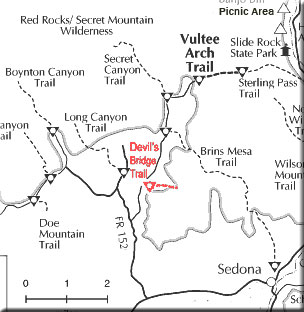
Directions To The Trailhead
From Sedona. Begin from the "Y" intersection of Arizona 179 and Highway 89A at uptown Sedona. From the intersection, drive west about 3 miles on 89A to Dry Creek Road. Turn north and drive 2 miles to Forest Road 152 which is also called Vultee Arch Road. Turn east on FR152 for about 1.3 miles to the trailhead parking lot.
FR152 is a rough dirt road, so a high clearance vehicle is suggested. A four-wheel drive vehicle is not required unless it is raining or icy. Admission is charged. As of June, 2012, fees are $5 per day ($15 per week, $20 for an annual pass) for a permit to park in the red-rock country of the Coconino National Forest.
Visitors can buy a permit at the junction of Dry Creek Road and FR 152 or at the Red Rock Ranger Station located at 8375 Highway 179 (south of the Village of Oak Creek). Passes may also be purchased a the Sedona-Oak Creek Canyon Chamber of Commerce Visitor Center at 331 Forest Road in Sedona or at many local shops and area lodging venues.
For More Information
Red Rock District
928-203-2900
Map To Devil's Bridge
Related Information
Attractions In The Sedona Area